How China’s cartographic campaign, passport warfare, and creeping administrative annexation are turning Arunachal Pradesh into the most dangerous naming dispute on the planet, and why neither side is entirely wrong.
A Routine Statement for a Growing Crisis
On the morning of April 12 2026 India’s Ministry of External Affairs issued a statement that has become very normal these days. They said that China had once again given “fictitious names” to places inside the Indian state of Arunachal Pradesh. The act was “mischievous”. The names were “baseless”. Arunachal Pradesh is and will always be an integral part of India. The statement was almost a copy of the statements issued in 2017 2021 2023, 2024, and May 2025.
The wording hasn’t changed because the issue hasn’t changed. What has changed is the magnitude. Since 2017, China’s Ministry of Civil Affairs has released six batches of official “standardized” names for geographical features inside Arunachal Pradesh Mountains rivers villages’ passes lakes in Chinese characters, Tibetan script, and Pinyin, with GPS coordinates and high-resolution maps.
The running total now stands at over 89 locations. The message in each list is the same: this territory is ours. We are just giving it the names it was meant to have all along.
China’s Argument: A Colonial Line, A Stolen Land
To grasp the reason why Beijing is repeatedly sending the lists, one needs to first understand what it thinks that it is fixing. China refers to Arunachal Pradesh as “Zangnan” South Tibet and its claim is not merely political opportunism. It is based on a historical point of view which, if China is right in one respect, should not be ignored: at the 191314 Simla Convention, the Chinese delegates were present at the border negotiations but refused to sign the final agreement Since then, Beijing’s position has been firm that Tibet, being a Chinese suzerain at that time, had no independent power to cede territory, and hence the McMahon Line drawn at that meeting is not legal. They consider the border drawn without the consent of China as no border at all. Chinese animosity is mainly towards the westernmost district of Arunachal Pradesh, Tawang.
It is not only a place of one of the most revered Tibetan Buddhist monasteries dating back to 1681 but also the birthplace of the sixth Dalai Lama. For a Beijing that has justified its control over Tibet on civilizational and religious grounds, Tawang is far from just a diplomatic concession. It is a spiritual claim. When India, in September 2024, decided to give the name of a mountain peak in Arunachal to the sixth Dalai Lama, China’s reaction was both promptly and strongly.
India’s Counter: Reality Over Rhetoric
India’s rebuttal is based on a very uncomfortable truth for Beijing: the reality on the ground. India holds the whole of Arunachal Pradesh whereas China doesn’t hold even a single part of it. The state has been under the Indian legal framework since 1947, was granted full statehood in 1987, and its 1. 4 million people Monpa Adi Tani, Nishi, and a dozen of other tribal groups have been voting in every Indian general election since independence. According to international law principles of uti possidetis juris and effectivits effective control and continuous administration the Indian claim is far superior.
As India’s External Affairs Minister S. Jaishankar put it bluntly: “If today I change the name of your house, does it become mine?”
Escalation on All Fronts: From Paper to Counties
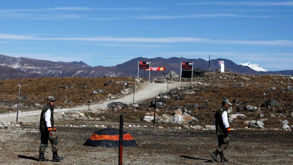
What makes the current moment different from previous rounds of this dispute is not just the renaming. It is the simultaneous escalation across multiple fronts. On March 26, 2026, just seventeen days before China’s latest renaming list, Beijing quietly established a new administrative county in Xinjiang called “Cenling,” near the Karakoram range and Pakistan-occupied Kashmir. It was the third such county carved near Indian-claimed territory in just over a year. The previous two, Hean and Hekang, already partially overlap with Aksai Chin, Indian-claimed territory under Chinese control since 1962. India has formally protested all three.
What these actions share is a common logic: if you cannot take territory by force, take it by paperwork. Rename the villages. Print them on official maps. Carve new administrative counties on adjacent land. Deny visas and passports that acknowledge your opponent’s sovereignty. Repeat, consistently, over decades, until the world begins to treat the claim as normal. Scholars call this “three warfares”, legal, media, and psychological, a doctrine designed to shift international perception without crossing the threshold of open military conflict.
The Passport Weapon: When Identity Becomes a Battleground
The dispute does not stay in the realm of maps and ministries. It lands in airport transit halls and passport offices, with ordinary people paying the price.
On November 21, 2025, Pema Wangjom Thongdok, a 35-year-old UK-based financial adviser from Arunachal Pradesh, was held for 18 hours at Shanghai Pudong Airport, in transit to Japan. Chinese officials declared her Indian passport “invalid” because it listed Arunachal Pradesh as her birthplace. Her travel documents were confiscated. She was denied food. China’s ban on Google and WhatsApp made contacting the Indian consulate nearly impossible for hours. She was eventually escorted out by Indian diplomatic staff.
This example was not a lone one. In 2023, India took its entire national Wushu team off from the Asian Games in Hangzhou after China had issued three Arunachal athletes “stapled visas” which are loose-sheet documents without stamping an Indian passport that recognizes the state as Indian Territory. The tradition goes back to 1980s, when the Chief Minister of Arunachal Pradesh was denied a Chinese visa because, as a Chinese they claimed, he was not supposed to need a visa to enter his own country.
India Pushes Back: Infrastructure as Sovereignty
India has not been a mere spectator. The Sela Tunnel, which was inaugurated in March 2024 and situated at an altitude of 13,000 feet, cuts down the time for military deployment to the eastern front from hours to minutes. The Vibrant Villages scheme is bringing back strategic border areas with permanent civilian population which is a move to counter China’s “Xiaokang” or well-off village construction along the LAC. After China approved the construction of a huge dam in Tibet near the Indian border in January 2025, India promptly approved the Siang Upper Multipurpose Project in Arunachal Pradesh as a counteract. Both nations are spending billions to turn the roof of the world into permanent, irreversible facts.
The international community has not been entirely silent either. In 2023, a bipartisan US Senate resolution formally recognised the McMahon Line as the legal boundary between Arunachal Pradesh and China, a pointed rebuke of Beijing’s position. Yet no major power has moved beyond symbolic gestures to directly challenge China’s administrative escalation. The renaming lists go largely unnoticed outside South Asia. The new Xinjiang counties barely register in Western news cycles.
The Forgotten Voice: The People Who Live There
The biggest victim of this dispute may be the one that is hardly ever talked about. The native peoples of Arunachal Pradesh the Monpa communities who have been worshipping at Tawang Monastery for three centuries, the Adi and Tani farmers in the valleys, the Nishi hunters of the foothills were not the ones who drew the McMahon Line. Neither Indian nationalism nor Chinese historical revisionism accurately represents who they are. Both powers have, at various points, replaced indigenous place names with their own. The mountain called Kangto has an older name still. Nobody in either capital is asking what it is.
No Resolution in Sight
This dispute will not be resolved by a renaming list, a new tunnel, or a Senate resolution. It will require two nuclear-armed states, together accounting for a third of humanity — to negotiate a border they have avoided formally demarcating for over sixty years. Until that discourse takes place, a 83,743-square-kilometre area of the Eastern Himalayas will remain a territory which is at the same time, defiantly, and dangerously two different things at once. When maps are being used as weapons, the first victim is not territory. It is the possibility of peace.